Made it home safely after 17 hours travel from London via Frankfurt via Vancouver to Victoria - not to mention the two hour drive in the middle of the night from Southampton to Heathrow. I am now home for a few days until I leave on November 19th to go to Mexico for a week (a vacation from my vacation).
Nothing like living your dream - over the last 11 months I have now travelled over 137,000 km which took 54 flights on 16 different airlines, visiting 16 different countries (sometimes more than once) - this has truly been a wild and wonderful adventure - I have not only learned so much about the world but I have the most amazing memories.
After Mexico I will be home for a few months (might need to get away from winter and do a short trip to Australia). However, I have paid a deposit for a South African safari on may 22, 2013. I am now making plans with Mag (friend of Sharon's from Ireland) who is going to join me and then we plan to travel around this area for a month with a goal to end up in Portugal in late June.
So stay tuned there will be more travels and more blogging - I hope you have enjoyed hearing about and seeing pictures of Lorna's traveling shoes!
Friday, November 16, 2012
Thursday, November 8, 2012
Quiet Man and Northern Ireland
I drove from Killarney to Galway (west coast of ireland) and then on to Clifden for a night. Clifden is located in another picturesque area of Ireland - lots of hiking, birdwatching and fishing. This is also the area where the John Wayne/Maureen O'Hara movie 'The Quiet Man' was filmed in 1951. OK some of you may be too young to have watched this film but it is a good classic movie with showing lots of beautiful irish scenery scenery - and visiting this area I am not disappointed as it looks just like in the movie. Ronanne and Lesley this will be our next classic movie night picture and I will make a traditional Irish stew!
 This is the bridge John Wayne stood on in the movie - this bridge was a block from my B&B


 One of the many old abandoned homes in Ireland
 Example of new homes
From Clifden I headed north through Donegal and then into Northern Ireland. Not sure exactly when you enter Northern Ireland as there isn't a border and no signage but the gas prices go to pounds from euros and kilometers change to miles. The other difference is that all road signs in the Republic of Ireland are in english and Irish gaelic whereas in Northern Ireland the road signs are in English only. Also like Scotland, Northern Ireland has their own currency as well as the pound except when you try to use Scottish or northern Irish currency in England they often will not take it!
Example of new homes
From Clifden I headed north through Donegal and then into Northern Ireland. Not sure exactly when you enter Northern Ireland as there isn't a border and no signage but the gas prices go to pounds from euros and kilometers change to miles. The other difference is that all road signs in the Republic of Ireland are in english and Irish gaelic whereas in Northern Ireland the road signs are in English only. Also like Scotland, Northern Ireland has their own currency as well as the pound except when you try to use Scottish or northern Irish currency in England they often will not take it!
Northern Ireland is a part of the United Kingdom in the north-east of the island of Ireland. It is variously described as a country, province or region of the UK. Northern Ireland shares a border with the Republic of Ireland to the south and west. As of 2011, its population was 1,810,900, constituting about 30% of the island's total population and about 3% of the population of the United Kingdom. Since the signing of the Good Friday Agreement in 1998, Northern Ireland is largely self-governing. According to the agreement, Northern Ireland co-operates with the rest of Ireland – from which it was partitioned in 1921 – on some policy areas, while other areas are reserved for the Government of the United Kingdom, though the Republic of Ireland "may put forward views and proposals".
Northern Ireland was for many years the site of a violent and bitter inter-communal conflict – the Troubles – which was caused by divisions between nationalists, who see themselves as Irish and are predominantly Roman Catholic, and unionists, who see themselves as British and are predominantly Protestant. (Additionally, people from both sides of the community may describe themselves as Northern Irish.) Unionists want Northern Ireland to remain as a part of the United Kingdom, while nationalists want reunification with the rest of Ireland, independent of British rule. Since 1998, most of the paramilitary groups involved in the Troubles have ceased their armed campaigns.
Stopped in Donegal for a quick coffee and gas - the weather has turned quite wet so no point in staying, I continued north to spend the night in Bushmills (Northern Ireland) so I could visit the Giant Causeway the next day. I arrived after dark in Bushmills and this was the first time I had not booked accommodation in advance. I could only see one hotel in the village and it had an AA rating so I thought I would check out the price. Let's just say I blew my budget on this hotel but it was very nice. The next day I realized all the B&B were located outside the village so I really should have booked in advance as they would have been too difficult to find in the dark.
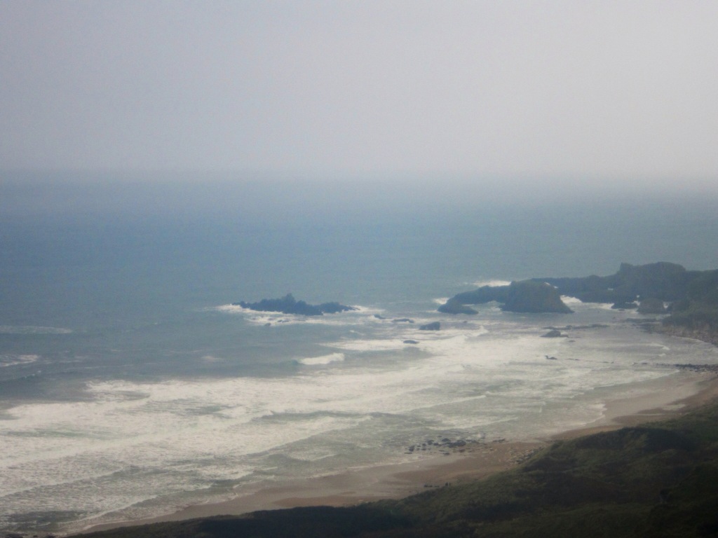
 Little detour I took to the ocean before Donegal


 Donegal

 Town of Bushmills
The day I was to visit the Giant Causeway the weather started out very wet with an Irish mist. One minute it was pouring with rain and the next there were patches of blue sky - makes for great rainbows with pots of gold and a leprechaun thrown in for good luck. You need to keep your humor because the weather is ever changing this time of year.
Town of Bushmills
The day I was to visit the Giant Causeway the weather started out very wet with an Irish mist. One minute it was pouring with rain and the next there were patches of blue sky - makes for great rainbows with pots of gold and a leprechaun thrown in for good luck. You need to keep your humor because the weather is ever changing this time of year.
The Giant's Causeway is an area of about 40,000 interlocking basalt columns, the result of an ancient volcanic eruption. It is located in County Antrim on the northeast coast of Northern Ireland, about three miles northeast of the town of Bushmills. It was declared a World Heritage Site by UNESCO in 1986, and a National Nature Reserve in 1987 by the Department of the Environment for Northern Ireland. In a 2005 poll of Radio Times readers, the Giant's Causeway was named as the fourth greatest natural wonder in the United Kingdom. The tops of the columns form stepping stones that lead from the cliff foot and disappear under the sea.
 Road to giant causeway


 Good view of the causeway in the mist


 I drove a section of the Giant Causeway Coastal Road between Bushmills and Ballycastle - the landscape is truly breathtaking!


 One of the tourist points on the Giant Causeway is the rope bridge that you can walk across. Not that I would even consider walking across this bridge but I did need to go and have a look. A short coastal footpath leads to Carrick-a-Rede Rope Bridge. On the way, there are wonderful vantage points to stop and take in the natural beauty. The geology, flora and fauna have won Carrick-a-Rede recognition as an area of special scientific interest.


Once in Ballycastle I drove through the town to the beach to get one last look at the Giant Causeway and the amazing scenery.


 Town of Ballycastle

I drove inland heading south bypassing Belfast and on to Dublin back to Sharon and her mum who have been such wonderful hosts. Thank you to Kathleen (Sharon's mum) for setting an iteninary of things I should see while traveling around ireland - you were spot on! I think kathleen has already started to work on the iteninary for my next visit!
 Kathleen and Sharon's lovely home

 This is the bridge John Wayne stood on in the movie - this bridge was a block from my B&B
 Scenes around Clifden . . .


Yes I drove on these roads with the help of Sally Sat Nav!

 One of the many old abandoned homes in Ireland
  Example of new homes
 Northern Ireland is a part of the United Kingdom in the north-east of the island of Ireland. It is variously described as a country, province or region of the UK. Northern Ireland shares a border with the Republic of Ireland to the south and west. As of 2011, its population was 1,810,900, constituting about 30% of the island's total population and about 3% of the population of the United Kingdom. Since the signing of the Good Friday Agreement in 1998, Northern Ireland is largely self-governing. According to the agreement, Northern Ireland co-operates with the rest of Ireland – from which it was partitioned in 1921 – on some policy areas, while other areas are reserved for the Government of the United Kingdom, though the Republic of Ireland "may put forward views and proposals".
Northern Ireland was for many years the site of a violent and bitter inter-communal conflict – the Troubles – which was caused by divisions between nationalists, who see themselves as Irish and are predominantly Roman Catholic, and unionists, who see themselves as British and are predominantly Protestant. (Additionally, people from both sides of the community may describe themselves as Northern Irish.) Unionists want Northern Ireland to remain as a part of the United Kingdom, while nationalists want reunification with the rest of Ireland, independent of British rule. Since 1998, most of the paramilitary groups involved in the Troubles have ceased their armed campaigns.
Stopped in Donegal for a quick coffee and gas - the weather has turned quite wet so no point in staying, I continued north to spend the night in Bushmills (Northern Ireland) so I could visit the Giant Causeway the next day. I arrived after dark in Bushmills and this was the first time I had not booked accommodation in advance. I could only see one hotel in the village and it had an AA rating so I thought I would check out the price. Let's just say I blew my budget on this hotel but it was very nice. The next day I realized all the B&B were located outside the village so I really should have booked in advance as they would have been too difficult to find in the dark.
 Little detour I took to the ocean before Donegal


 Donegal
B&B in Bushmills - the over the budget one!


 Town of Bushmills
 The Giant's Causeway is an area of about 40,000 interlocking basalt columns, the result of an ancient volcanic eruption. It is located in County Antrim on the northeast coast of Northern Ireland, about three miles northeast of the town of Bushmills. It was declared a World Heritage Site by UNESCO in 1986, and a National Nature Reserve in 1987 by the Department of the Environment for Northern Ireland. In a 2005 poll of Radio Times readers, the Giant's Causeway was named as the fourth greatest natural wonder in the United Kingdom. The tops of the columns form stepping stones that lead from the cliff foot and disappear under the sea.
 Road to giant causeway


 Good view of the causeway in the mist


Of course, Carrick-a-Rede also boasts an exhilarating rope bridge experience. Traditionally fishermen erected the bridge to Carrick-a-Rede island over a 23m-deep and 20m-wide chasm to check their salmon nets. Better them than me!
The rope bridge originally consisted of a single rope hand rail which has been replaced by a two hand railed bridge by the National Trust. Once you reach Carrick Island, the reward is seeing the diverse birdlife and an uninterrupted view across to Rathlin Island and Scotland. There is only one way off the island - back across the swinging bridge! Unless you stay on the one side and just take pictures!
It was a kilometer from the car park to the bridge so at least I am getting some walking excerise today.


Once in Ballycastle I drove through the town to the beach to get one last look at the Giant Causeway and the amazing scenery.

If you look hard you can see a couple of black dots - those are surfers


Public art at the beach 


Love the sign - perhaps suited for Oak Bay
It was very difficult to say goodbye to this part of Ireland as I knew this would be the last time I would see the Irish coast - for now anyway! I'll be back! The coast of Ireland is unlike anything I have seen before - simply the best!I drove inland heading south bypassing Belfast and on to Dublin back to Sharon and her mum who have been such wonderful hosts. Thank you to Kathleen (Sharon's mum) for setting an iteninary of things I should see while traveling around ireland - you were spot on! I think kathleen has already started to work on the iteninary for my next visit!
 Kathleen and Sharon's lovely home
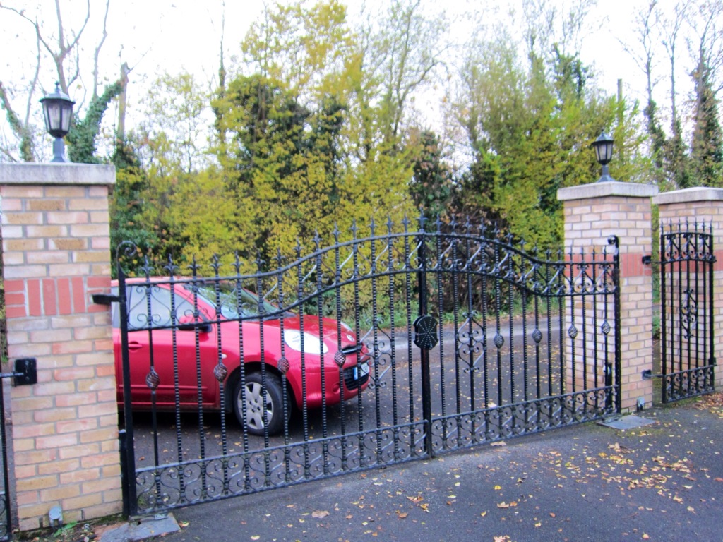
My rental car outside the gates.
I am off back to England tomorrow to spen a few days with relatives before I return to Canada on November 15th. I have fallen in love with Ireland so I hope to take the luck of the Irish with my on my next travels.
Wednesday, November 7, 2012
Traveling around Ireland
Before I describe my travels around Ireland I would like to do an update on my last post to give some information on the Temple Bar. The Temple Bar is not only a bar but it is also and the name of an area in Dublin where numerous bars and restaurants are located and is a very lively area full of music and fun seekers in the evening. The name Temple dates back to the 1600's when the bar got its name from Sir William Temple who purchased land in this area. Although he was Sir William Temple he was often linked with sleaze, corruption and greedy land speculation damaging standards of morality and politics in Ireland.
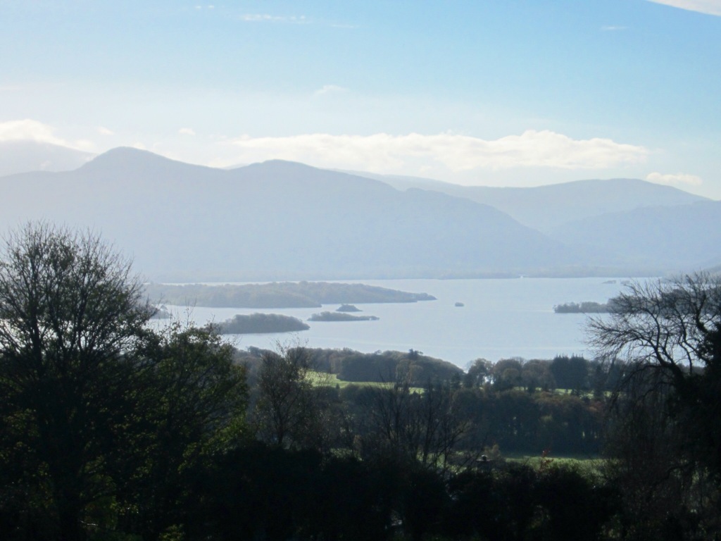
Traveled from Cork to Killarney to catch a 6 hour tour of the Ring of Kerry (costing $18 - who says Ireland is expensive). I could drive the ring of Kerry but decided to enjoy the views and take advantage of someone else driving and beside gas is about $2 a liter here so it would probably cost me more than $18 to drive. Almost immediately the landscape changes when leaving County Cork and entering County Kerry (where Killarney is located). Gone are the lush green rolling hills for more rugged mountains (well mountains by Ireland standards) and a lot less greenery.


 The Ring of Kerry is a tourist trail in County Kerry, south-western Ireland. The route covers the 179 km circular road, starting from Killarney, heading around the Iveragh Peninsula and passing through Kenmare, Sneem, Waterville, Cahersiveen and Killorglin. First stop was overlooking Killarney to get some fabulous photos above.
Kerry Bog Village - In Ireland two factors contribute to the existence of peat lands (soil made up of the partially rotted remains of dead plants which have accumulated on top of each other in waterlogged places for thousands of years)- high rainfall and poor drainage conditions. Bogs are very acidic. It is this acidity that helps preserve the excellent condition of 'bog bodies' (human bodies discovered in bogs, usually victims.of ritual sacrifice from long ago). Peat resources can be used for fuel as well as insulation- originally 17 percent of Ireland was covered with bogs! I avoided seeing any bog bodies but I did tour through the village laid out as it would have looked in the 1800's.
Between 1845 – 1852 famine devastated Ireland. The great famine was in fact one of the worst famines in modern history. A large portion of the population died or emigrated. Such was the drastic effect of the famine that many historians refer to Ireland as pre-famine or post-famine. Potato blight meant the potato crop failed and as a result left many Irish farmers and households without food. However, the potato failure alone did not cause the famine. It was a host of political, social and economic factors which all contributed.
An astonishing amount of food, animals and materials were exported by force from the country, at a time when it was needed most by the natives. The great famine was undoubtedly the darkest time in Irish history. Starvation, disease, emigration and mass graves were all prevalent during these awful years.
What village might have looked like . . .


 Single person home most likely a local laborer
 Pile of peat
 A real bog pony - were close to extinction in the late 1980's - today the breed is back to healthy numbers. These ponies were used for transport and farm work such as bringing home turf from the bog, seaweed from the beach and bringing milk to the creamery. They were useful as people carries too and because they were smaller than horses they eat less and take up little space. I think Hannah would like one of these in her San Francisco back yard!
Naturally there was a pub on the site of the village and their speciality is Irish coffees. Ok, it is only 11am but I needed to do a taste test! Yummy!
A real bog pony - were close to extinction in the late 1980's - today the breed is back to healthy numbers. These ponies were used for transport and farm work such as bringing home turf from the bog, seaweed from the beach and bringing milk to the creamery. They were useful as people carries too and because they were smaller than horses they eat less and take up little space. I think Hannah would like one of these in her San Francisco back yard!
Naturally there was a pub on the site of the village and their speciality is Irish coffees. Ok, it is only 11am but I needed to do a taste test! Yummy!
The following are pictures of the landscape we got to see while travelling the Ring of Kerry.
 Yes the sky is really this blue - we are so lucky as often there is mist in this area.
 The colors are amazing from the blue sky to lush green hills to the spectacular green and blue water. The last time I saw water this color was in the Caribbean.
 Charlie Chaplin had a home in a little town on the Ring of Kerry - his family still has a home in this area


 Simply stunning views - like no where else that I have visited


 Beautiful beach I did not expect to see in Ireland

 The water is actually this color

 Another section of the Ring and such a change in the landscape


 Old abandoned church.

 My B&B in Killarney

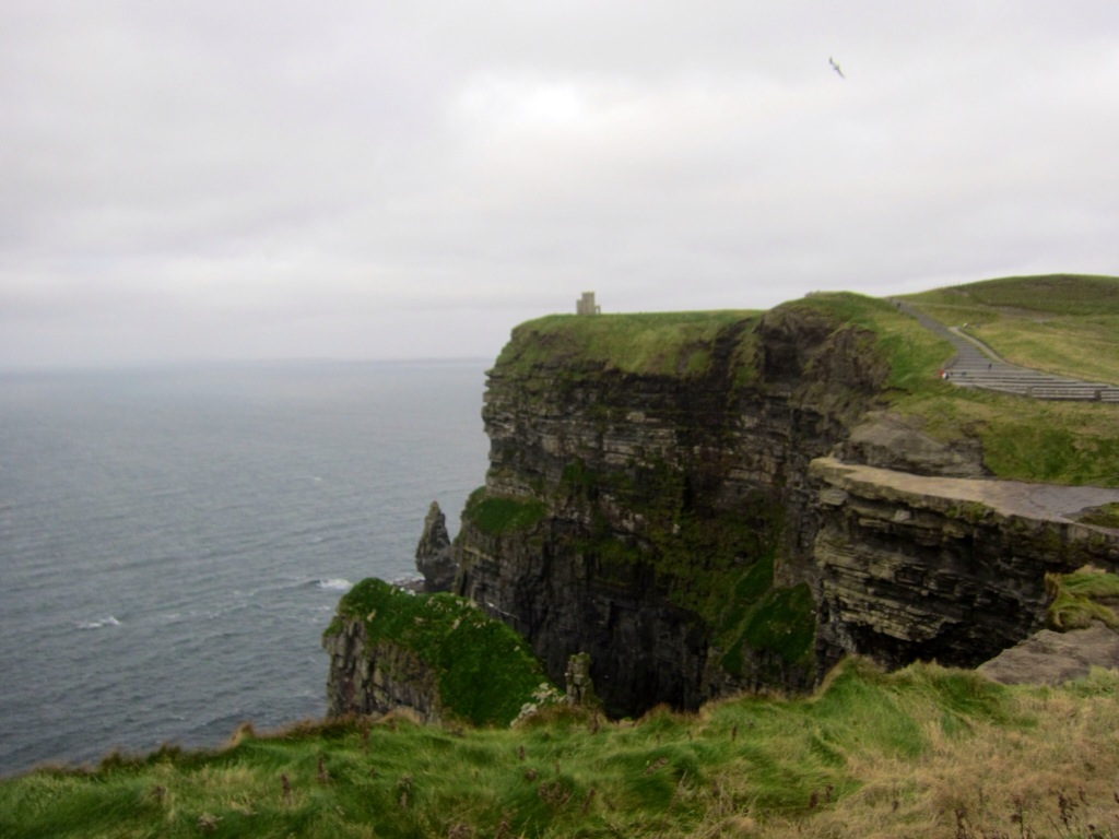
O'Brien's Tower is a round stone tower near the midpoint of the cliffs built in 1835 by Sir Cornelius O'Brien to impress female visitors. From the cliffs and from atop the watchtower, visitors can see the Aran Islands in Galway Bay, the Maumturks and Twelve Pins mountain ranges to the north in County Galway, and Loop Head to the south.


 Leaving the Cliffs of Moher I traveled through the Burren area towards Galway and the on to Clifden. The rolling hills of Burren are composed of limestone pavements with criss-crossing cracks known as "grikes", leaving isolated rocks called "clints". The region supports arctic, Mediterranean and alpine plants side-by-side, due to the unusual environment. The limestones, which date from the Visean stage of the Lower Carboniferous, formed as sediments in a tropical sea approximately 350 million years ago. The strata contain fossil corals, crinoids, sea urchins and ammonites.
The entire area is picturesque and was exactly how I imagined this part of Ireland to be. The lovely little towns, fields divided by endless rock walls with limestone hills in the background.

 Cannot figure out how they build these rock walls with no cement between the rocks


 One of the roads I traveled on coming out of the hills is called the corkscrew - incredible scenery but I opted to keep my hands on the steering wheel. This charming landscape is truly unique to Ireland. Hope you enjoy!
Traveled from Cork to Killarney to catch a 6 hour tour of the Ring of Kerry (costing $18 - who says Ireland is expensive). I could drive the ring of Kerry but decided to enjoy the views and take advantage of someone else driving and beside gas is about $2 a liter here so it would probably cost me more than $18 to drive. Almost immediately the landscape changes when leaving County Cork and entering County Kerry (where Killarney is located). Gone are the lush green rolling hills for more rugged mountains (well mountains by Ireland standards) and a lot less greenery.


Kerry Bog Village - In Ireland two factors contribute to the existence of peat lands (soil made up of the partially rotted remains of dead plants which have accumulated on top of each other in waterlogged places for thousands of years)- high rainfall and poor drainage conditions. Bogs are very acidic. It is this acidity that helps preserve the excellent condition of 'bog bodies' (human bodies discovered in bogs, usually victims.of ritual sacrifice from long ago). Peat resources can be used for fuel as well as insulation- originally 17 percent of Ireland was covered with bogs! I avoided seeing any bog bodies but I did tour through the village laid out as it would have looked in the 1800's.
Between 1845 – 1852 famine devastated Ireland. The great famine was in fact one of the worst famines in modern history. A large portion of the population died or emigrated. Such was the drastic effect of the famine that many historians refer to Ireland as pre-famine or post-famine. Potato blight meant the potato crop failed and as a result left many Irish farmers and households without food. However, the potato failure alone did not cause the famine. It was a host of political, social and economic factors which all contributed.
An astonishing amount of food, animals and materials were exported by force from the country, at a time when it was needed most by the natives. The great famine was undoubtedly the darkest time in Irish history. Starvation, disease, emigration and mass graves were all prevalent during these awful years.
What village might have looked like . . .


 Note the small windows and doors - people were taxed on the number and size of windows and doors.
 Single person home most likely a local laborer
Family home


 A real bog pony - were close to extinction in the late 1980's - today the breed is back to healthy numbers. These ponies were used for transport and farm work such as bringing home turf from the bog, seaweed from the beach and bringing milk to the creamery. They were useful as people carries too and because they were smaller than horses they eat less and take up little space. I think Hannah would like one of these in her San Francisco back yard!
 The following are pictures of the landscape we got to see while travelling the Ring of Kerry.


Taken through bus window while moving! 


Honestly I did take these pictures 


 Another section of the Ring and such a change in the landscape
Town where we had lunch 
Again a different area of the Ring 

You must watch for sheep when driving. Although there are lots of rock walls to attempt to keep them on their owner's property they are often found walking down the middle of the highway - I almost hit one! Farmers dyes a color spot on the back of each sheep to identify which ones belong to him as these little guys tend to visit each other.


Seems there are deer issues here too!


Downtown Killarney - population 15,000
A few things I have noticed about Ireland:
1. The friendly people
2. Extremely clean - towns, villages, highways, yards - everyone takes pride in their home and community
3. It is not nearly as expensive as I was led to believe - no more expensive than Victoria and in some cases less - B&B above was $55 for the night - could not get that in Victoria!
4. Very easy to drive around Ireland - well signed, although Sally sat nav (GPS in NA) is helpful except for a few hiccups! Drivers are very polite. You look at the map and think it will not take long to get from a to b, however most highways are not 4 lane freeways but rather two lane (or less) roads that wind their way through numerous towns - which is great for those of us sightseeing. There is also endless road construction. I did see one interesting sign it had a gas pump with a circle around it and a cross through it, next to it was a bicycle with the slogan 'burn fat not gas' - great advertising.
5. You do see some stone houses but most have been abandoned - most homes are fairly new, modern and large which reflects the booming economy up to 2008. Now some of the new developments have not been completed and a number of businesses are for sale.
6. It is sad to see signs pointing to a Famine Graveyard - but a good reminder of how this country was affected.
After a night in Killarney I made my way to the Cliffs of Moher - the weather was more overcast and much cooler as I reached the coast. Walking from the parking lot to the cliffs was quite a challenge trying to fight the strong winds.
The Cliffs of Moher are located at the southwestern edge of the Burren region in County Clare, Ireland. They rise 120 metres (390 ft) above the Atlantic Ocean at Hag's Head, and reach their maximum height of 214 metres (702 ft) just north of O'Brien's Tower, eight kilometres to the north. The cliffs receive almost one million visitors a year.O'Brien's Tower is a round stone tower near the midpoint of the cliffs built in 1835 by Sir Cornelius O'Brien to impress female visitors. From the cliffs and from atop the watchtower, visitors can see the Aran Islands in Galway Bay, the Maumturks and Twelve Pins mountain ranges to the north in County Galway, and Loop Head to the south.


The entire area is picturesque and was exactly how I imagined this part of Ireland to be. The lovely little towns, fields divided by endless rock walls with limestone hills in the background.


Subscribe to:
Posts (Atom)