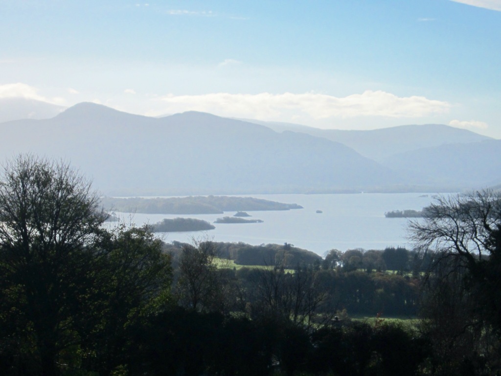
Traveled from Cork to Killarney to catch a 6 hour tour of the Ring of Kerry (costing $18 - who says Ireland is expensive). I could drive the ring of Kerry but decided to enjoy the views and take advantage of someone else driving and beside gas is about $2 a liter here so it would probably cost me more than $18 to drive. Almost immediately the landscape changes when leaving County Cork and entering County Kerry (where Killarney is located). Gone are the lush green rolling hills for more rugged mountains (well mountains by Ireland standards) and a lot less greenery.


Kerry Bog Village - In Ireland two factors contribute to the existence of peat lands (soil made up of the partially rotted remains of dead plants which have accumulated on top of each other in waterlogged places for thousands of years)- high rainfall and poor drainage conditions. Bogs are very acidic. It is this acidity that helps preserve the excellent condition of 'bog bodies' (human bodies discovered in bogs, usually victims.of ritual sacrifice from long ago). Peat resources can be used for fuel as well as insulation- originally 17 percent of Ireland was covered with bogs! I avoided seeing any bog bodies but I did tour through the village laid out as it would have looked in the 1800's.
Between 1845 – 1852 famine devastated Ireland. The great famine was in fact one of the worst famines in modern history. A large portion of the population died or emigrated. Such was the drastic effect of the famine that many historians refer to Ireland as pre-famine or post-famine. Potato blight meant the potato crop failed and as a result left many Irish farmers and households without food. However, the potato failure alone did not cause the famine. It was a host of political, social and economic factors which all contributed.
An astonishing amount of food, animals and materials were exported by force from the country, at a time when it was needed most by the natives. The great famine was undoubtedly the darkest time in Irish history. Starvation, disease, emigration and mass graves were all prevalent during these awful years.
What village might have looked like . . .


 Note the small windows and doors - people were taxed on the number and size of windows and doors.
 Single person home most likely a local laborer

 A real bog pony - were close to extinction in the late 1980's - today the breed is back to healthy numbers. These ponies were used for transport and farm work such as bringing home turf from the bog, seaweed from the beach and bringing milk to the creamery. They were useful as people carries too and because they were smaller than horses they eat less and take up little space. I think Hannah would like one of these in her San Francisco back yard!
 The following are pictures of the landscape we got to see while travelling the Ring of Kerry.


 Another section of the Ring and such a change in the landscape


Seems there are deer issues here too!


Downtown Killarney - population 15,000
A few things I have noticed about Ireland:
1. The friendly people
2. Extremely clean - towns, villages, highways, yards - everyone takes pride in their home and community
3. It is not nearly as expensive as I was led to believe - no more expensive than Victoria and in some cases less - B&B above was $55 for the night - could not get that in Victoria!
4. Very easy to drive around Ireland - well signed, although Sally sat nav (GPS in NA) is helpful except for a few hiccups! Drivers are very polite. You look at the map and think it will not take long to get from a to b, however most highways are not 4 lane freeways but rather two lane (or less) roads that wind their way through numerous towns - which is great for those of us sightseeing. There is also endless road construction. I did see one interesting sign it had a gas pump with a circle around it and a cross through it, next to it was a bicycle with the slogan 'burn fat not gas' - great advertising.
5. You do see some stone houses but most have been abandoned - most homes are fairly new, modern and large which reflects the booming economy up to 2008. Now some of the new developments have not been completed and a number of businesses are for sale.
6. It is sad to see signs pointing to a Famine Graveyard - but a good reminder of how this country was affected.
After a night in Killarney I made my way to the Cliffs of Moher - the weather was more overcast and much cooler as I reached the coast. Walking from the parking lot to the cliffs was quite a challenge trying to fight the strong winds.
The Cliffs of Moher are located at the southwestern edge of the Burren region in County Clare, Ireland. They rise 120 metres (390 ft) above the Atlantic Ocean at Hag's Head, and reach their maximum height of 214 metres (702 ft) just north of O'Brien's Tower, eight kilometres to the north. The cliffs receive almost one million visitors a year.O'Brien's Tower is a round stone tower near the midpoint of the cliffs built in 1835 by Sir Cornelius O'Brien to impress female visitors. From the cliffs and from atop the watchtower, visitors can see the Aran Islands in Galway Bay, the Maumturks and Twelve Pins mountain ranges to the north in County Galway, and Loop Head to the south.
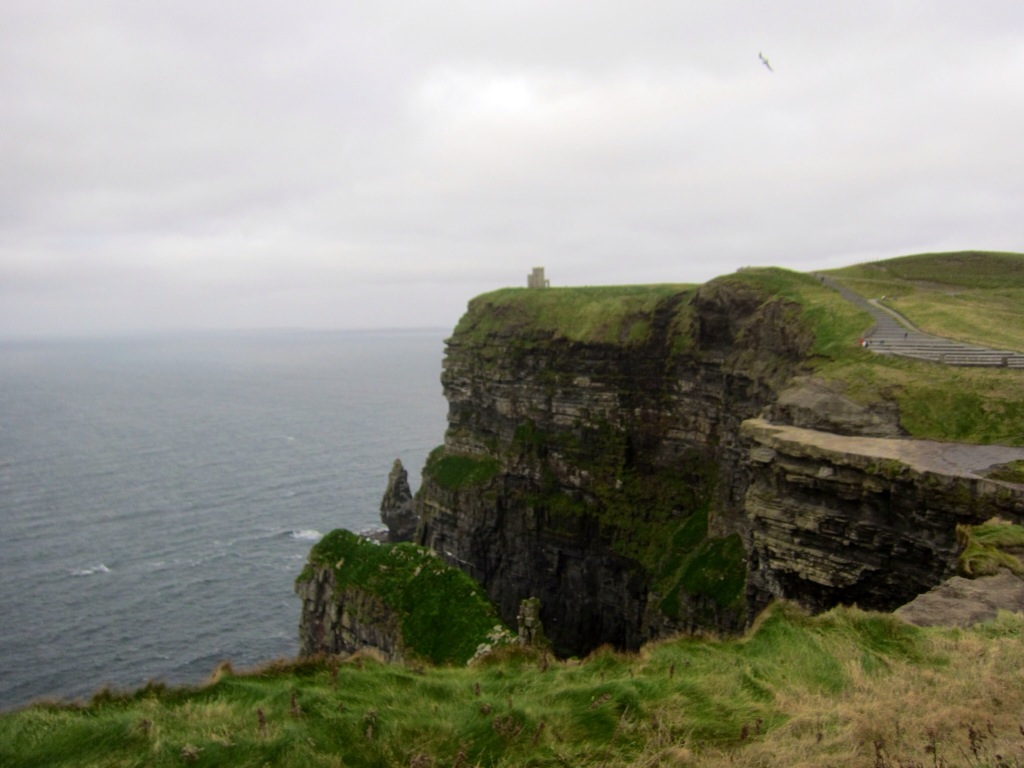


The entire area is picturesque and was exactly how I imagined this part of Ireland to be. The lovely little towns, fields divided by endless rock walls with limestone hills in the background.


No comments:
Post a Comment